Showing posts with label bridges. Show all posts

Monday, April 22, 2013

Early morning @ Cansaga Bay


I stayed with my friend J for a couple of days on Holy Week when I was in Cebu.  J woke me up early on Maundy Thursday and we took a 15-minute ride on her husband's motorbike to get to the new bridge in Consolacion.  This 1.25-kilometer offshore bridge over Cansaga Bay provides a faster link between the sea and airports to the northern towns of Cebu.

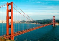
The above photo is looking towards Mandaue City.  On the left side of the bridge is a locally-owned shipyard.


By the banks of Cansaga Bay and under the bridge was a makeshift fish market where local fishermen bring their morning catch.  Fish and other seafood were sold on bamboo tables under a half dozen of huts.   It was Holy Week and J and her family, like most Cebuanos, observe the no-meat tradition. We were hoping to buy shrimps and crabs for lunch. It was about 7 am when we got here, and I thought we were early. I later learned that most of the action here happens before sunrise.  Most of the seafoods were sold out and fishermen were already taking a break, some were taking a nap, and eating breakfast.


Luckily,  there was still some fresh catch coming in and we were able to bring home shrimps, crabs, oysters and shellfish.  


This reminds me of the early morning walks with my grandmother when I was a kid. My grandparents' house was about a kilometer away from the sea, and Lola (that's how we called our grandmother) would take us kids to the shores early in the morning to wait for fishermen to bring in their catch. And while our grandmother was negotiating with the fisherman, we were busy choosing small squids, shrimps and anchovies for ceviche. And the fishermen didn't charge us for our ceviche ingredients. Ah, it was a gentler time.


Cansaga Bay is an inlet where the mouth of Mactan Channel and Camotes Sea meet.


Linking to


Saturday, February 4, 2012

Makeshift bridge/Sunday Bridges


A makeshift bridge at a beach resort crossing a small creek that leads to a mangrove.  Various vehicles crossed this bridge---a motorbike, a tricycle, a pick-up truck, and a carabao-driven carriage.


My contribution to Sunday Bridges

Saturday, January 21, 2012

Sunday Bridges/Rural bridge


A tiny wooden bridge in Busuanga Island I spotted on the way to the airport.  Took this photo from the back of the moving van.


Linking to Louis' Sunday Bridges

Saturday, January 14, 2012

Circular/Saturday Photo Hunt


Circular concrete culverts at the embankment of a river in Manapla, Negros Occidental.


Linking to Saturday Photo Hunt


Saturday, January 7, 2012

Sunday Bridges/Trece Martires bridge


I miss participating in Louis' Sunday Bridges and visiting beautiful bridges around the world.  Well, here's my contribution today---a steel truss bridge in Trece Martires City, the capital of Cavite province, about 42 kilometers south of Manila.  Drove across this bridge a day after Christmas to visit a friend in Trece Martires City.  Had to park on the side of the highway to take this photo.:p


Linking to Sunday Bridges

Monday, August 29, 2011

Blue Monday: Bridge

@ mirandablue

Blue ropes in one of the bridges at Fontana Hotel and Leisure Park in Clark.


Join us at Blue Monday

Sunday, May 22, 2011

Manapla bridge

@ mirandablue
It's been a while since I participated in Sunday Bridges.  Now I'm back!  I was with my cousins in Manapla a few weeks ago.  My cousin had some business here, and the meeting place was at the banks of this river.:p  I have no idea what this river is called---people were swimming and doing their laundry.  The bridge looks frail but in a couple of hours that we were by the banks of the river, there were trucks, motorbikes, tricycles and even a horse that passed through it.  I hope the next storm wouldn't destroy this bridge.

@ mirandablue
This is the river down-stream...
@ mirandablue


Posted for Sunday Bridges


Sunday, March 20, 2011

Old and new [Sunday Bridges]

@ mirandablue
Two-in-one drive-by shot during our road trip more than two weeks ago--a new bridge and an old one still standing.  Again, I don't have a clue what this river or bridge is called.  This was after Binalbagan bridge, so this must be near the boundary of Himamaylan City. Himamaylan is about 83 kilometers south of Bacolod City, the provincial capital.


More bridges at Sunday Bridges

Sunday, March 13, 2011

Binalbagan bridge [Sunday Bridges]

@ mirandablue
Taken from our road trip last week in the southern part of Negros island, my home province.  I don't know the name of this bridge but the billowing smoke at the background came from the chimneys of a sugar central called BISCOM in Binalbagan town.  Truckloads of cut sugarcane came through this bridge everyday during milling season. A new bridge replaced the old truss bridge but the metal railings remained.

@ mirandablue


Posted for Sunday Bridges

Sunday, February 20, 2011

Fontana bridge

@ mirandablue
A bridge over a man-made pond in Fontana Leisure Park.  This bridge leads to the swimming pool and picnic areas.  Fontana, located inside the Clark Ecozone, has a hotel and casino.  We recharged here on Sunday afternoon after the exhausting Hot Air Balloon Fiesta.

@ mirandablue


Sunday, January 9, 2011

Nalusuan Island foot-bridge [Sunday Bridges]


A 260-meter wharf and foot-bridge at Nalusuan Island near Mactan, Cebu.


Only those who will risk going too far can possibly find out how far one can go.  
~T.S. Eliot


This is linked to Sunday Bridges

Sunday, December 26, 2010

Market! Market! flyover [Sunday Bridges]

@ mirandablue
One of the methods implemented by the government to curb the high volume of vehicles in the streets of Metro Manila during peak-hours is the Number Coding Scheme.  Vehicles are prohibited in the streets for a certain day in a week, specifically on Mondays, vehicles with plate numbers ending in 1 and 2 are not allowed from 7 am to 7 pm; 3 and 4 on Tuesdays, 5 and 6 on Wednesdays and so on until Friday.   I had an appointment one Friday afternoon early this month and my car wasn't allowed to be in the streets that day.  So I took a cab and had the chance to take some photos along the way.  This is one of the flyovers along C5 Road that connects traffic to Bonifacio Global City, an upscale business and residential area.  The cab driver gave me some curious glances when he noticed I was taking photos.:p

@ mirandablue

the other end of the flyover


Posted for Sunday Bridges

Sunday, December 5, 2010

Three bridges and a lizard

@ mirandablue
There are three bridges here and a lizard about to jump off the bridge! 

I'm kidding about the lizard, of course.  I didn't notice it until it crawled across my windshield.  Poor little thing.  As for the bridges, these three are at the intersection of Ortigas Avenue and C5 Road, a 19.7-kilometer beltway which stretches from Taguig City to Quezon City in Metro Manila.  I was on Ortigas Avenue going east, on my way home on a late Saturday afternoon...traffic flow was slow as usual.  

The Ortigas Avenue interchange is one-way from the east going west to EDSA, north and south to C5 Road---my usual route when going to work.  The skyway is a two-way bridge along C5 that crosses over the Ortigas Avenue interchange.

Posted for Sunday Bridges

Sunday, November 21, 2010

Ayala Avenue flyover [Sunday Bridges]

@ mirandablue
This is Monday morning traffic as I was approaching the Ayala Avenue tunnel going to Roxas Boulevard.  Above the tunnel is the Ayala Avenue and EDSA intersection, on top is the drab Ayala flyover.  Also seen is the footbridge crossing EDSA.  Ayala Avenue is one of the busiest thoroughfares in Metro Manila, crossing through the heart of Makati's central business district.  Because of the many businesses located on the avenue, Ayala Avenue is nicknamed the Wall Street of the Philippines.  When the MRT (Metro Rail Transit) was constructed, the flyover was added for left turners to EDSA.


Posted for Sunday Bridges

Sunday, November 14, 2010

Stone bridge [Sunday Bridges]

@ mirandablue
A stone bridge over a small lagoon that leads to the marble wall etched with Jose Rizal's "Mi Ultimo Adios" and a diorama of his execution.  Located in Rizal Park, Manila.


Sunday, October 24, 2010

Patapat Viaduct

@ mirandablue
Before leaving Pagudpud and going back to Laoag City, we drove to Patapat Viaduct, a 1.3-kilometer concrete coastal bridge at the foot of the cliff of the north Cordillera mountain range.  Driving through the winding mountain road without traffic was a delightful experience.  This viaduct rises 31 meters above sea level, offering scenic views of the lush Cordillera mountains and the enchanting Pasaleng Bay.  It connects Maharlika Highway from Laoag City to the Cagayan Valley region.

Maharlika Highway is a 2500-kilometer network of roads, bridges and ferry services that connects the islands of Luzon, Samar, Leyte and Mindanao.  It starts in Laoag City and ends in Zamboanga City.

@ mirandablue
Before the viaduct was constructed [during the Marcos administration], landslides were a common occurrence in this area during rainy season making this stretch a dreaded one-way road. In the 1960's, a footbridge perched on the mountain slope was the only link between the provinces of Ilocos and Cagayan Valley.  The etched footbridge can still be seen at the upper part of the cliff.  

This was the farthest point of our Ilocos road trip---about 580 kilometers from Manila.

@ mirandablue


Sunday, October 17, 2010

Pagudpud Bridge [Sunday Bridges]

@ mirandablue
This bridge greeted us before we entered Pagudpud, our destination.  I am not sure if this is the bridge that crosses Bolo River, a river that separates the towns of Bangui and Pagudpud.  Shooting the rapids and kayaking are popular in Bolo River.  Exploring Bolo River is for another trip.


Posted for Sunday Bridges